In the year 2010, I decided to read the Bible through again after a two or three year lapse. In reading the Exodus, it struck me that God had Moses put in an amazing amount of detail concerning the crossing of the Red Sea. The exact location and a description of just how it was done are in amazing contrast to the description of God parting the waters of the Jordan, where it is merely said that when the feet of the Priests touched the water, the water was stopped and heaped up near the city of Adam and the Jordan dried up. There are no details given, as there are for the crossing of the Red Sea. God does nothing without a reason, so it would seem we should be able to find from the Bible account just where the crossing took place and how it was worked out.
Let's start with the Bible and trace the movement of the Israelites. Exodus 13:17 & 18 state that God didn't let them use the coastal route which was the shortest way to the promised land, because they weren't ready to fight their way through. Instead he sent them through the way of the wilderness. There were essentially two routes across Sinai. The first and most widely used went up the coast. The other swung south and then east across central Sinai, and then back north to the west of the mountains along the Gulf of Aqaba.
Numbers 33 says that the Israelites left Rameses on the 15th of Abib (usually given as our April) and camped in Succoth, then in Etham at the edge of the wilderness. Num 33:5: "And the children of Israel removed from Rameses, and pitched in Succoth". Num 33:6: "And they departed from Succoth, and pitched in Etham, which is in the edge of the wilderness". Succoth means 1"booths".
Rameses was traditionally located by archeologists at Tanis, but in the last few years that idea has been proven wrong. It was actually in the southeastern part of the Delta, on the Pelusiac branch of the Nile, right next to the former Hyskos capital of Avaris, which became a suburb of it. The "Way of the Philistines" ran right past the front door - all the Israelites had to do was step on to it and head northeast! But instead they headed southeast.
Succoth has never been located. By the meaning of the name, I would guess it was a caravan staging area, where caravans were put together to leave Egypt, and broken up on arriving in Egypt. Since it was only occupied sporadically and for short periods, there probably were no permanent structures, but people lived in tents and crude structures (booths). This would have been a logical place for the final Israelite assemblage before leaving Egypt. Since there were no permanent structures in Succoth, it will probably never be located. It may have been on the outskirts of an established community and long since been built over. Since the Isrealites had a choice of routes, Succoth may have been where the two caravan routes joined in Egypt.
The meaning of Etham is said to be unknown. I guessed it was probably not Hebrew, but a transliteration of a local name. (A similar sounding Hebrew word, Etam, though spelled differently, means "aerie", but this is probably not relevant.) Etham would seem to denote an area, or a type of terrain, as well as a place, as after the Red Sea crossing they are said to be in the "wilderness of etham". The thought occurred to me that it could be the gulf of Aqaba, but then why wouldn't the Bible refer to God parting the waters of Etham? I then guessed Etham was a prominent landmark in or on the edge of the mountainous area surrounding the gulf of Aqaba, which would have been the "wilderness of Etham". After that I dropped it and moved on to the next point, but later on in my research came across a mention of "Wadi Al Ithim" in an account by Charles Beke2 of his trip up Aqaba in 1874, he mentions visiting Wadi Ithim, which was northwest of Aqaba, and which he supposed was Elim (very doubtful in my mind as it is too far north and doesn't fit into the Biblical chain of events). However, Ithim (Ethim) sounds very much like Etham. It's meaning in Arabic is to accuse3. This doesn't help much, as the name gives no indication of the exact location of Etham. Wadi Ithim at first would seem to be too far north. The Israelites would already be past the top of the Gulf of Aqaba and out of Pharaoh's reach - but then the Bible does say that God turned them back so that he could show the Egyptians once and for all who was God:
Exo 14:3 For Pharaoh will say of the children of Israel, They are entangled in the land, the wilderness hath shut them in. Exo 14:4 And I will harden Pharaoh's heart, that he shall follow after them; and I will be honoured upon Pharaoh, and upon all his host; that the Egyptians may know that I am the LORD. And they did so.
I now believe Wadi Ithim is the Etham of the Bible. It was the way east from the head of the gulf of Aqaba, and is now the route of the Jordanian highway east from Aqaba. It is also on the "edge of the wilderness" (pastureland) east of Aqaba. As a matter of fact, Exodus 23:31 gives the location of both Yam Suph and "the wilderness": Exo 23:31 And I will set thy border from the Red Sea even unto the sea of the Philistines, (Aqaba on the east to the Mediterranean on the west) and from the wilderness unto the River: (Mountains bounding Aqaba on the south to the Euphrates on the north) for I will deliver the inhabitants of the land into your hand; and thou shalt drive them out before thee. No one would argue that the land God gave the Israelites included Egypt, or even the Sinai peninsula, so Yam Suph has to be the Gulf of Aqaba, which is reinforced by other scriptures: Deuteronomy 1:2 and Numbers 14:25. The wilderness (pastureland) are the two mountain ranges to the east of Aqaba which also extend up to the Dead Sea. So Mt. Sinai would actually be three days journey from Etham, but more on this later.
There are seemingly unlimited number of arguments online for why Mt. Sinai couldn't be any further east than the traditional Jebel Musa, most all of them based on the idea that the Israelites couldn't have gotten that far. However, soldiers have marched across Sinai in 6 days, and Beke did it in 8 from Aqaba to Suez by camel. The Israelites were driving flocks and herds, and had a number of oxcarts (not the fastest form of transportation!), so they would have taken longer.
The only time line given in the Bible is that the Israelites left Egypt on 15 Abib (Nisan) and arrived at Mt. Sinai on the 15th day of the second month (Lyar). This means the trip took 29 - 30 days. Even if it took them 16 - 18 days to cross to Wadi Ithim, and another 3 - 4 to backtrack to Pihahiroth, they still had plenty of time. Another common argument is that the traditional site must be correct, as the traditions are so old. However, the traditions were begun in the 4th century AD, about 1700 years after the fact. People then had even less to go on than we have today.
I do believe the Bible shows the Israelites were already in Sinai at this point, as it is said in Exodus 14:8: "the children of Israel went out with an high hand". Also in Exodus 13:17,18 it would seem that God had already led them on the southern route rather than the northern one. Egypt controlled western Sinai, but it was not considered part of Egypt. The eastern part was known as a "wilderness". Exo 14:3 says: "For Pharaoh will say of the children of Israel, They are entangled in the land, the wilderness hath shut them in". The Bible also seems to indicate that Pharaoh didn't decide to pursue the Israelites until they had turned back and camped at Pihahiroth where they seemingly couldn't possibly escape, but this is not necessarily fact - he may have left earlier.
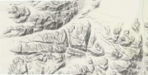
Another reason I hold this view is the way that God opened the sea for them. A high wind blowing across flat country and onto a sheet of water may shift the whole sea one way, like a tide, but it won't blast a path clear to the sea floor with walls of water on each side. To do that, the wind would have to be concentrated downwards at one point. A funnel shaped valley with the wide end towards the east, sloping downwards, with the small end near sea level, would be required. Looking at shuttle photos and satellite maps, I see no such valley on the west side of Sinai. The Gulf of Suez also seems to be too wide for a wind to blow open a passage across.
The Bible says in Exo 14:2: " Speak unto the children of Israel, that they turn and encamp before Pihahiroth, between Migdol and the sea, over against Baalzephon: before it shall ye encamp by the sea. As this was the wilderness, I believe all these names refer to natural features, not towns or populated areas. " Pihahiroth, pronounced "pee hah-khee-roth", means "mouth of the gorge". (In 1 Kings 17:3 Elijah stayed by the brook "Cherith", which means "a cut".) Migdol usually is translated as "watchtower", but it also can refer to an elevated natural land mass. So God is telling the Israelites to camp at the mouth of a sharp sided valley between a squarish, flat topped landmass and the sea.
Baalzephon: Baal means "god". The Ba'als were storm gods. Zephon is usually translated "winter", so this would make the translation the "God of Winter". It actually means dark, hidden, and is associated with the north and wind. Some believe it is the Egyptian form of "Typhon", and I concur with this. Typhon was a monstous storm-giant with two twisted vipers for legs who issued forth winds deadly to sailors. (http://www.theoi.com/Gigante/Typhoeus.html) This fits perfectly with Baalzephon (Ba'al Typhon) not being an idol, or temple as most have supposed, but a place feared by sailors because of the destructive winds that issued from it at times. The twisted valleys leading down to the water across from Pihahiroth may have suggested the serpent legs of Typhon. These valleys likely captured and funneled the east wind - one in particular has the required funnel shape to do just that.
http://www.geonames.org/maps/google_29.083_35.1.html .
According to Charles Beke2, (Page , who sailed up the gulf of Aqaba in 1874, the wind usually blows from the north down the Gulf of Aqaba, sometimes up from the south. Evidently east winds are unusual, and are associated with cyclonic storms coming up the Arabian coast.
It was while I was pondering the meanings of these words one evening at work that I noticed a pile of old National Geographics in the corner of the art room and leafed through them to see if there were any maps. There were none, but I happened upon an article on Sinai from 1982 and turned to a photo of "Neviot" (Neweiba Beach) back when the Israeli's controlled the area. At once I said to myself "That's it!" It fitted the Biblical description exactly.
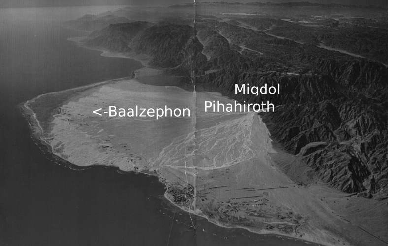
I used Gimp to remove most of the pipelines, cottages, and gardens found here so that it would look more as it did when the Israelites camped here. (today it is a resort!). Notice the square, roughly flat-topped mountain (The Migdol).
It was at this time I also found out that a man named Ron Wyatt had come to the same conclusion, though I have also found he has made a lot of dubious claims. Later I found out that Charles T. Beke had also believed the Israelites had crossed the Gulf of Aqaba, though he was more concerned with finding "the real Mt. Sinai" than with where they crossed. He also had some very strange ideas and made dubious claims, but his account of his trip up the Gulf of Aqaba is useful.
One of the chief difficulties with the crossing is the depth of the water. Aqaba is very deep and steep sided, but evidently in this spot it is shallower. To determine how much shallower I need a decent navigational chart. The second difficulty is the strength of the wind. Even funneled into one spot, the wind would have to be very strong. Wind gusts above about 45 mph will blow people over. See: wind effect on pedestrians. Wherever the Israelites crossed, I doubt it was a walk in the park!
Normal tidal levels range from 3 - 4 feet, as determined by Charles Beke at Aqaba on Feb. 6, 18742, pages 446, 447, 453, and confirmed by the "Red Sea Pilot"5, page 263. A proxigean spring tide would have a bigger range, and this may have occurred at the time the Israelites crossed. I considered planetary alignments, but found they would have no noticeable effect.
I have also found that the sea level 3400 - 3500 years ago was nearly 2 meters lower than it is today4. In fact, the sea level dropped by about 2.25 meters over an approximately 400 year period between about 3800 years ago and 3400 years ago. This sudden a drop was probably caused by a major volcanic eruption causing global cooling and glaciation. It would also coincide almost exactly with the 430 years the Israelites were in Egypt, and a volcanic eruption could have caused the famine of Joseph's time.
Together these factors could have resulted in a sea level approximately 3 - 4 meters lower than presently normal at the time the Israelites crossed, but there is another factor that works in the Gulf of Aqaba that has more effect than the tides. This is the wind, which pushes water out of the Gulf when it blows from the north, and back in when it blows from the south. The period when it blows most strongly from the north ends in March or April, about the time the Israelites crossed. The water level would have been at its lowest at this time.
Even these factors wouldn't fully account for the Israelites being able to cross this portion of the Gulf of Aqaba, but there is one more factor noted in Scripture: Exo 15:8 "And with the blast of thy nostrils the waters were gathered together, the floods stood upright as an heap, and the depths were congealed in the heart of the sea". According to the Scriptures, the wind was cold enough to freeze the deepest parts of the sea. This effect was used in the 2004 movie "The Day After Tomorrow", however scientists say this couldn't really occur because the air drawn from the upper atmosphere would warm too much on the way down. This is probably true on the scale shown in the movie, but if done on a smaller scale and concentrated in one particular area it might well be. In any case, this is what the Scripture claims, and nothing is impossible for God!
While my purpose was to determine where the Israelites crossed the Red Sea, the theory wouldn't work out unless the places and events after the crossing fit in. Exodus 15:22 says: "So Moses brought Israel from the Red sea, and they went out into the wilderness of Shur; and they went three days in the wilderness, and found no water". Numbers 33:8 says: "And they departed from before Pihahiroth, and passed through the midst of the sea into the wilderness, and went three days' journey in the wilderness of Etham, and pitched in Marah". These two verses seem on the surface to be contradictory, but I doubt if the areas in question had boundaries "surveyed by a licensed surveyor". They probably overlapped or were different names for the same area. We have already discussed Etham. "Shur" means "the wall". This is an area to the south of Baalzephon, starting just south of the border of Tabuk Province (N 28 40' 20"/E 34 49' 3") and running to the Tayyib Al Ism area (N 28 30' 13"/E 34 47' 59"). This is described in Travels in Arabia p. 1536 as "A very remarkable appearance is produced on the opposite shore by the valleys, which rise between the mountains in a solid slope of sand, to the height of two thousand feet. The intermediate coast presents a steep wall (emphasis mine), rising in many places six thousand feet; the surface is dark, veined with numerous traces of torrents of a lighter colour, every where intersecting it." This area would have been impossible for the Israelites to ascend or cross, so they would have had to go inland.
Looking at some of the names in the account, however, most of the names after the crossing appear to be either of Arabic origin, or originated in the same original language that Arabic did. This is another evidence that Yam Suph was the Gulf of Aqaba. Alush has no meaning in Hebrew but the Hebrew translates over to Arabic as "Aloosh"  , probably meaning "moderation". Dophkah converts to
  and means "I knock" in Arabic. Sin has no meaning in Hebrew, but means "desert" in Arabic. Elim supposedly means "Palms" in Hebrew, but the Hebrew doesn't translate directly to Arabic. Its primitive root, meaning "strong man, ram, tree" in Hebrew
  translates as a similar sounding word, "Elimah"
  , which means Ram in Arabic but is likely translated correctly as Palm Tree. Sinai is likely
  , pronounced "seenah" in modern Arabic and meaning "tooth", a reasonable description for a mountain. Horeb means "waste" in Arabic, as in "wasteland". Only Rephidim is not of Arabic origin - it means "ballusters" in Hebrew. There are a number of megalithic sites along the coast from Yemen up to Jordan that would fit this description, however I believe this is one place that is easy to pinpoint. From the transactions of the Bombay Geographical Society p175: "--at the entrance of wady Omaider Rubeer some of them are composed of short pillars somewhat thicker at the base than the upper part, rising in irregular rows one above the other" 7. This is a perfect description of Rephidim! "Wady Omadier" is the present day Wady Humaydah (29014'11.18" N 34056'19.08" E, occupied by the town of Al Humaydah, just south of Al Haql in Saudi Arabia.
To be continued. Last updated: 30-Jan-2013 12:46 PM